
Peru - a far away country
It was pure coincidence, that I stumbled over a guided tour in "heygo", which was about architecture in Lima. I had nothing else to do, so I booked the tour, being more interested in architecture, than in Lima, if I shall stick to the truth. But then there was that guide, Vanessa, talking so vividly and committed about her city, that she awoke my curiousity about that country.
Because - what do you know about Peru? What did I know about Peru? I had a quarter of brainstorming all by myself - and this is, what I came up with ...
country in South America, capital Lima, Inca, Nazca-lines, Machu Picchu - ruin city in the Andes, conquistadores, Simón Bolívar, Lake Titicaca, Austria beat Peru in some soccer-WC long ago, Quechua, the flag: red-white-red in vertical stripes, Humboldt-current and el Niño. Well, that was about everything.
|
Not much ... No culture, no painters, writers, nothing about society.
On the other hand it isn't so much less than I know about other countries. Most people don't even know the little I came up with, I guess. And that is the trouble of mankind - to look further than the immediate surroundings, to think outside of the own box, to be afraid of different behaviour; all of this boosts xenophobia and fear of others.
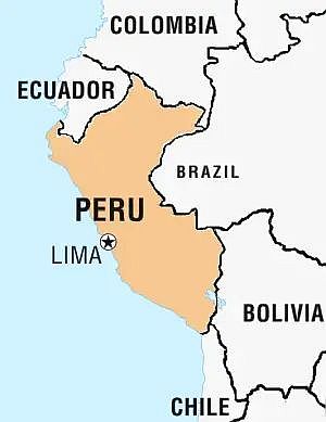
That is why I decided to do something about it. I'll find out things, in order to learn more myself and maybe to contribute to that others learn something as well. So, let's start. But where? Peru lies to the south of Ecuador, thus it must be south of the Equator as well. I thought. Yes, it is mainly correct, but Peru also is located east of Ecuador, with its northernmost point almost at the Equator. (Already some new knowledge.) From there it forms the southern boundary to Colombia. The many headwaters of the Amazon finally build that mighty river, entering Brazil, which is part of Peru's eastern border, before Bolivia takes over. To the south the country borders to Chile. And all the way in the west there is the Pacific Ocean.
Peru has an area of 1286000 square kilometers, which is exactly twice as large as France.
|
 |
This is the next surprise; I never would have thought that it is so big. On the other hand there live little more than 31 million people - which is surpassed by no less than seven European countries: Germany, France, Great Britain, Italy, Spain, the Ukraina and Poland. Then again a lot of the area in Peru consists of desert, rain forest and mountains, where it - for a dense population - is impossible to settle.
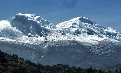
The highest mountain is called Nevado Huascaran and is with its 6746 meters a good kilometer higher than the Elbrus, which is the highest mountain in Europe, in the Kaukasus.
|
 |
|
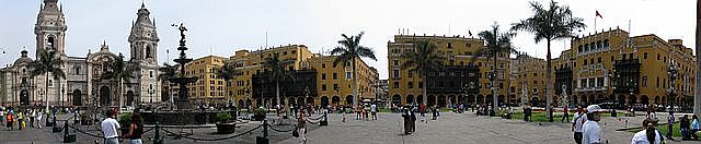
Lima is the biggest city and the capital of the country, with almost ten million people living there. The image below shows the Plaza Mayor. The city is located on the coast, approximately in the middle of the country's north-south extension.
|
|
On the other hand, there are no really big cities in Peru, apart from Lima. Second is Arequipa, with just over one million inhabitants. This city is to be found very much at the south of the country and is also called "the legal capital of Peru", as the Constitutional Court of Peru is seated here. Third among cities is Trujillo, at the coast in the north-western part, with almost a million people.
|
All the rest of the cities have about half a million or less inhabitants. Chiclayo, Oiura, Huancayo, Cuzco and Chimbote follow in this order.
There are three official languages in Peru. Spanish is spoken by most people; about eighty percent are proficiant in this language. Quechua and all its dialects are spoken all over the western Part of South America, with focus on the highlands in Peru and Bolivia. The third official language of Peru is Aymara, but only a little percentage of people speak it in the southern parts of the country. It is mainly spread in Bolivia.
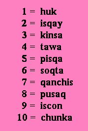
But let us go back to Quechua and let us see, how much of that language all of us know: are you familiar with "condor, puma, llama, pampa, coca and quinine (sort of medicine)? They all have their origin in Quechua. And as numbers are very important in any language, in the table to the right you can see the numbers from one to ten in Cuzco dialect. A good thing: if you know those, you can easily go on counting to at least one hundred.
|
 |
|
When South America separated from Africa and drifted westwards, the greatest resistance came - of course - at the west coast, which is the reason that the mountain range of the Andes was building up. Between the Andes and the Pacific there is a very narrow strip of land, but that consists almost entirely of desert. Precipitation is very low, in Lima it generally never rains. The reason for this is the cold Humboldtstream in the ocean, cooling down the air, so that there is no evaporation, that could build clouds.
|
On the other hand it can be quite foggy, bringing the little moisture that there is. The only possibility for agriculture are and were therefore the river valleys.
It is scientifically proven, that people were living in those valleys, as early as 10000 BC.
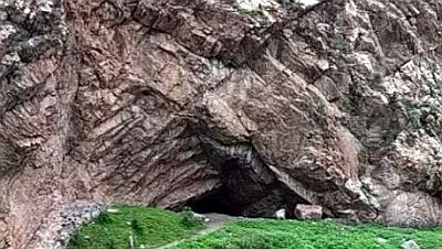
At that time they were hunters and gatherers. But stone tools show, that there must have been people using them. Examples for this period are the Guitarrero Cave (image) in the Andes, in the Yungay province, to the north of Lima, and the Callejón de Huaylas, both along the Rio Santa.
|
 |
At about 7000 BC the first settlements appeared. This made it possible to engage in farming, which
led to population growth. Now people settled at the coast as well, in fishing communities. Huaca Prieta and Kokosh are early examples. There are lots of archeological places during the following millennia, with some cultural artifacts here and there. But the first recognized culture arose around 1500 BC, the Cupisnique culture.
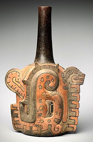
Though it is seen as the first pre-Colombian culture, experts do not agree on its duration, neither on its influence on later cultures. In my opinion it seems to be quite clear, that the Chavín culture was directly influenced, as they emerged at the same place as the Cupisnique and furthermore used the same iconography and religious symbols. Chavín is said to have been dominant from 900 to 200 BC, so there might have been a direct transition from the Cupisnique.
To the right you see a bottle, which is described as "a caiman body and feline head". But if you know, that the condor, the puma and the snake were symbols for the air, the earth and the underground, you will soon notice, that the caiman is no crocodile, but a snake. And the feline head might very well be the head of a puma.
Even the Moche (or Mochica) culture is said to be influenced by the Cupisnique. It had its heyday between 100 - 800 AD.
|
 |
The Moche people were centered at the northern coast of Peru, with its center at the Moche valley near Trujillo.
Naturally even the Moche culture was influenced from the earlier, but nearby cultures of Cupisnique and Chavín. Among other things they adored the Spider God, which can be seen on some containers.
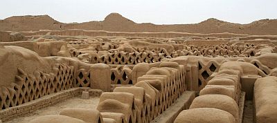
After the Moche followed the Kingdom of Chimor along the northern coast. They made the city of Chan Chan their capital, situated in the Moche valley, but closer to the coast. The Chimú became very wealthy, but were looted heavily by the Inca, when the latter expanded northwards.
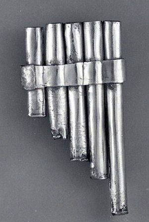
To the right you see an early Chimú panpipe, made of silver. The image below shows rests of adobe walls in Chan Chan. They survived the millennia because of the dry climate, where no rain caused any deterioration to this fragile material.
|
 |
In the southern part of Peru emerged the Paracas culture, which was the ancestor of the Nazca culture. Both existed at the same time as the northern Chavín and Moche era.
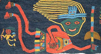
From the Paracas era remain a lot of mummies and not at least textiles, due to the very dry climate. Much of the textile was used to wrap the bodies of the deceased, resulting in so called "mummy bundles". Many pieces were richly embroidered, like the one on the image to the right, showing flying(?) people.
|
 |
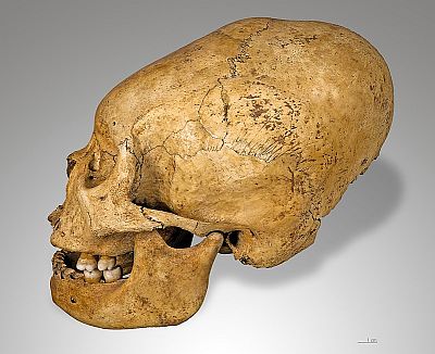
Something interesting, which started during the Paracas period, was the elongated form of the sculls. It is explained by archeologists through some hard wrapping of a child's skull, to make the head growing larger. Personally I doubt that this was possible to the extent, that we today still can see in museums. The head can be deformed, but the volume can't grow by putting pressure on it. Besides, not everybody is convinced, that this was done by external force. Some experts think that it may have been a genetic exeption.
The Paracas culture was adopted by the Nazca population, which overtook much of the older culture.
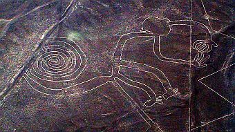
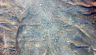
This era is mainly known because of the Nazca lines, fascinating drawings into the soil, very big, so that they only can be seen from the air.
|
 |
There are straight lines for hundreds of meters, and there are pictures of animals, etc. The question remains, how it could have been done - and why? The individual figures are sized from 400 to 1100 meters - how could you ever draw those without looking at them from above? Below you see the monkey and the hummingbird, but there are many, many more.
I have read a lot of the Swiss author Erich von Däniken. Considering all this said above, it strenghtens his theory of "alians" or "Gods" having visited our globe. Just put together those lines, which only can be seen from far above, with the images of flying men. Add the oblong skulls, originated by some genetic intermixture of the "visitors" with native girls - and you are not very far off Dänikens thoughts.
|
A couple of centuries later the Inca appeared. It is not clear, where they came from. They founded the capital of Cuzco and expanded all the way of the western part of South America, until they themselves were almost eradicated by the Spanish conquerers. But the story of the Inca is a different chapter.
This is of course only a very short description of the human development in Peru, but it is a lot more, than I had known before. And, as I have said so many times before, the people of the world wouldn't be so terrified by different behaviours, if we knew more about each others cultures.
|
Copyright Bernhard Kauntz, Västerås 2022
Back to  or to the or to the  of of
last update: 24.8.2022 by webmaster@werbeka.com
|